Resection
Overview
Reference material for Resection in WinTAK, sourced from the official WinTAK 5.7 Software User Manual (26 March 2026).
Manual Reference

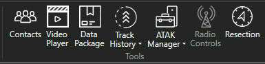
The Resection Tool provides a capability to users without a GPS signal to estimate their location from known points/landmarks on the map. Two or more reference points on the map are needed to provide a more accurate estimate of the user's location. To use, select the Resection Tool from the main toolbar.
Placing landmarks

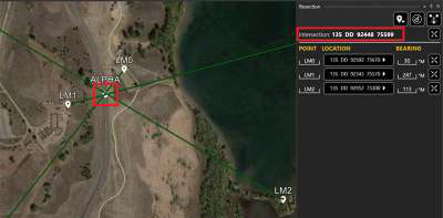
From their position, the user identifies and places a series of landmarks on the map. Landmarks are placed using the Add Landmark icon from the Resection tool, then selecting the landmarks on the map. Once the landmark is placed, the bearing relative to the user's position can be adjusted by selecting the desired landmark entry and modifying the bearing value.
As landmark points are placed, the intersection continues to be updated in the Intersection field.

Plotting the intersection

To plot the intersection location at any time, select the Plot Intersection icon and the current intersection point will be placed on the map.
If additional landmark points are added, the intersection point will be updated and the Plot Intersection icon can be selected again, and an updated intersection point will be placed on the map.
Moving and removing landmarks
To move a landmark point, right-click the point on the map and then select another location for the point. To remove an individual landmark point, select the landmark point on the map to bring up the radial and select the Delete radial option. Other landmark point radial options include: R&B Line, Polar Coordinate Entry, Fine Adjust and Details.
To delete all landmark points that have been placed on the map, select the Clear Landmarks icon and confirm deletion of all landmark points.

Source
WinTAK Software User Manual, Version 5.7, 26 March 2026, page 22.